
Artificial Intelligence
AI Being Employed to Predict Wildfires with Greater Accuracy
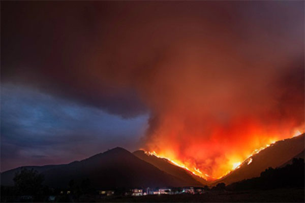
By John P. Desmond, AI Trends Editor
As wildfire risk has grown larger and more destructive in recent years, especially in the drought-plagued West, AI is being employed to assess wildfire risks more accurately and sound the alarm hours earlier after fire breaks out.
For example, the Nature Conservancy is using controlled burning techniques in forests in California’s Sierra Nevada susceptible to wildfires. This summer, on a 28,000-acre plot near Lake Tahoe, the group plans to test an AI program designed to assess how well the thinning plan will prevent fires.
“Nothing is going to completely replace the human brain to make decisions, but AI can help us make better decisions across a much larger area,” stated Edward Smith, forest ecology and fire manager at the Nature Conservancy, based in Arlington, Va., in a recent account in The Wall Street Journal.

The AI program will use satellite imagery of pre- and post-thinning work to make the assessments. This has been made possible by the availability of small satellites taking more photos of forests, and powerful computers needed to process the data.
Microsoft’s launch in 2017 of “AI for Earth,” which allowed the general public access to AI tools that can be used to process data from satellites as a cloud service, gave a boost to the work. Microsoft issues some grants to help defray the cost of the research for certain issues, including wildfire prevention.
“We’re flying blind now,” stated Lucas Joppa, chief environmental officer for Microsoft. “We have no idea what the state of our national forests are in the US, yet I can point you to a coffee shop in a millisecond.”
SilviaTerra LLC of San Francisco began using the Microsoft network about a year ago to build a map of the nation’s forest based on data from satellites, including the Landsat program run by the US Geological Survey and NASA. The firm hopes to map more than 400 million acres of forest for the project, called Basemap, to help guide thinning work.

AI is helping the company do with a workforce of 10 what it would take thousands to do without. It. “One person can measure maybe 20 acres in a day,” stated Zack Parisa, co-founder of SilviaTerra. “With AI, you can do a whole forest.”
Salo Sciences of San Francisco is developing a product incorporating AI to map areas of highest wildfire risk, based on an analysis of dead and dying trees. The firm is concentrating on California, where an estimated 150 million trees died during a five-year drought earlier in the decade.
“Some of the data that goes into state wildfire risk maps is 15 years old,” stated Dr. Dave Marvin, co-founder and CEO. He formed the company with Christopher Anderson, a graduate student from Stanford University. “We saw we needed to bring together a new framework of how you take satellite imagery and data and more rapidly inform conservation efforts,” stated Dr. Marvin.
In similar work, a team of experts in hydrology, remote sensing and environmental engineering have developed a deep-learning model that maps fuel moisture levels in fine detail across 12 western states, from Colorado, Montana, Texas, and Wyoming to the Pacific Coast, according to a recent press release from Stanford University.
The technique is described in the August 2020 issue of Remote Sensing of Environment. The senior author of the paper, Stanford University ecohydrologist Alexandra Konings, the new dataset produced by the model could “massively improve fire studies.”

The paper’s lead author, Krishna Rao, a PhD student in Earth system science at Stanford, said the model needs more testing to be used in fire management decisions, but is revealing previously invisible patterns. Over time, it should help to “chart out candidate locations for prescribed burns,” Rao stated.
The Stanford model uses a recurrent neural network, an AI system that can recognize patterns in vast volumes of data. The scientists trained the model using data from the National Fuel Moisture Database, which has compiled some 200,000 measurements since the 1970s using a painstaking manual method. The researchers added measurements of visible light bouncing off Earth, and the return of microwave radar signals, which can penetrate through leafy branches all the way to the ground.
“Now, we are in a position where we can go back and test what we’ve been assuming for so long – the link between weather and live fuel moisture – in different ecosystems of the western United States,” Rao stated.
“One of our big breakthroughs was to look at a newer set of satellites that are using much longer wavelengths, which allows the observations to be sensitive to water much deeper into the forest canopy and be directly representative of the fuel moisture content,” stated researcher Konings.
Read the source article in The Wall Street Journal and read the Stanford University press release.


Quotex Trading App Strategy Tips and Tricks

Ensuring Durability and Protection: The Importance of Roof Repair in Escondido

How to Make Food Delivery App like DoorDash in 2024 (Step-by-Step)

How to Connect with Random People Online

Mastering Samsung FRP Bypass: A Comprehensive Guide

Price Drop Alert- For Just $25/month, Get Nomad Raptor, Nomad Internet’s Fastest Modem Yet

Seizing the Future: Prime Metaverse Investments for 2024

Mens Surgical Scrub Cap and Nursing Scrub Cap for Health Care Professional

From Code to Creativity: How Amit Srivastava Is Shaping the Future of Artificial Intelligence

Smm panel genuine techniques and policies | gotosmmpanel

The Imperative of Responsive Web Design in Today’s Digital Era

Breaking News: Private Helicopter Tours Service In Atlanta Is Fusing With M.V.P Atlanta | Dujaun Hayles Is Elevating Atlanta’s Luxury Vehicle Experience

5 Ways Mainstream Media Misreports Events

Site GPT: Redefining Website Content Creation with AI

Why Tracking Your Spending Is Key to Financial Success

Maximizing Profit Margin: Key Strategies for Business Success

Importance of Digital Marketing for Small and Medium Enterprises (SMEs)

Sastanaqqam at WOW Summit & Art Basel Hong Kong: A Leap Towards the Future of Digital Art

Top SEO Solution cover all methods to improve a website’s ranking
