
The Indonesian archipelago did not emerge as a nation through roads or borders. It took shape along water. For more than two millennia, sea lanes threaded together islands now separated on maps but historically bound by exchange, negotiation, and movement. To travel these waters by yacht today is to experience continuity rather than reenactment. The routes remain active. Only the cargo has changed.
Private yacht experiences in Indonesia across eastern waters does not replicate ancient trade. It follows its contours. Currents still dictate direction. Seasonal winds still matter. Narrow straits retain strategic gravity. The difference lies in pace and intention. Where spices, resins, ceramics, and textiles once moved under pressure of profit and power, contemporary yachts carry people seeking comprehension through presence.
This form of travel occupies an unusual position within luxury travel Indonesia. Comfort exists, yet the emphasis rests on context rather than spectacle. The journey unfolds across corridors shaped long before modern tourism vocabulary existed.
The Archipelago as a Maritime Network
Indonesia comprises more than 17,000 islands officially recorded by the Indonesian Geospatial Information Agency. Over 63 percent of its territory is maritime, according to the Ministry of Marine Affairs and Fisheries. These figures do more than describe scale. They explain structure.
Long before the Common Era, Austronesian-speaking peoples developed ocean-going vessels capable of sustained blue-water travel. Archaeological and linguistic evidence places Indonesian sailors across the Indian Ocean by the first millennium CE. Historian K.N. Chaudhuri described Southeast Asia as “a vast zone of maritime interaction, held together by monsoon winds and commercial necessity” (Trade and Civilisation in the Indian Ocean, Cambridge University Press).
Trade routes passing through what is now Indonesia connected China, India, the Middle East, and East Africa. Ceramics from the Tang and Song dynasties appear in shipwrecks off Java. Roman glassware has been excavated in Sumatra. These findings confirm that Indonesian waters functioned as arteries rather than margins.
A yacht tracing these paths encounters geography shaped by that legacy. Straits narrow deliberately. Islands cluster near choke points. Anchorages align with historical ports.
Monsoon Logic and Seasonal Movement
Ancient trade depended on predictability rather than speed. The monsoon system offered that reliability. Northeast and southwest monsoons reversed direction seasonally, allowing sailors to plan round trips with precision.
That logic remains intact. Yacht captains planning a yacht expedition Indonesia still calculate passages against wind shifts and sea states. Eastern Indonesia, in particular, reflects this seasonal rhythm. The Banda Sea, Flores Sea, and Maluku waters open or close depending on month and direction.
This continuity influences onboard life. Days underway mirror ancient routines: early departures, midday rests at anchor, evenings defined by shelter rather than schedule. Modern forecasting improves safety, yet does not eliminate dependence on weather.
The experience reveals why trade ports clustered where they did. Sheltered bays near monsoon transitions offered security. Deep channels near reef systems balanced access with defense.
The Spice Routes of Maluku
Few commodities shaped global history as decisively as spices from eastern Indonesia. Nutmeg and cloves, native to the Maluku Islands, commanded prices in early modern Europe that rivaled precious metals. At various points in the 16th and 17th centuries, nutmeg sold for several hundred times its weight in silver.
Historian Fernand Braudel wrote that spices “were luxury goods par excellence, and their circulation linked the fate of distant continents” (Civilization and Capitalism, University of California Press). Control of Maluku trade routes fueled European colonial expansion.
Sailing through Banda or Seram by yacht today strips away that violence while retaining geography. Volcanic islands rise sharply from deep water. Anchorages remain exposed. Distances between safe harbors remain meaningful.
A private yacht holiday through Maluku becomes an exercise in spatial literacy. Passages follow routes dictated by reef gaps and prevailing winds. Shore visits reveal remnants of forts and trading posts, now absorbed into daily village life.
Luxury yacht charter Indonesia in this region feels inseparable from historical awareness. Movement carries narrative weight.
Makassar, Bugis Sailors, and Indigenous Networks
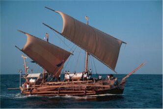
The Bugis and Makassarese sailors of South Sulawesi maintained trade networks independent of European control. Their pinisi vessels reached as far as northern Australia, exchanging goods and knowledge.
Anthropologist Christian Pelras documented that Bugis traders operated through flexible alliances rather than centralized authority, allowing adaptation to shifting conditions (The Bugis, Blackwell Publishing). This decentralization contrasts sharply with colonial monopolies.
Modern yachts share the same waters. Makassar remains a maritime hub. Traditional pinisi still launch alongside steel-hulled yachts.
Island hopping Indonesia through this corridor reveals continuity rather than nostalgia. Local fishing vessels follow routes refined over generations. Harbors function as social spaces as much as logistical ones.
The coexistence of traditional and modern vessels reinforces perspective. Technology evolves. Maritime logic persists.
Komodo and the Eastern Passage
The waters around Komodo sit along a historic corridor between western and eastern Indonesia. Strong currents funnel between Flores and Sumbawa, creating both opportunity and risk.
UNESCO designated Komodo National Park a World Heritage Site in 1991, recognizing not only its terrestrial species but its marine ecosystems shaped by these currents. For traders, the passage offered access between markets. For sailors, it demanded skill.
A Komodo Islands yacht charter traces that tension. Timing matters. Tidal exchanges remain powerful. Anchorages require precision.
Approaching Komodo by yacht aligns with historical use rather than touristic consumption. The park appears as a waypoint rather than an endpoint. Dragons inhabit land. The sea dictates movement.
This perspective reframes a familiar destination. Control lies with nature rather than itinerary.
Raja Ampat and Peripheral Exchange
Raja Ampat occupied a peripheral position in ancient trade, yet its role mattered. Bird-of-paradise plumes, resins, and forest products moved westward through Papuan networks. Exchange followed kinship lines rather than imperial control.
Marine biodiversity now defines the region’s global reputation. A 2002 Conservation International survey documented over 500 coral species and more than 1,600 fish species. That richness reflects long-term ecological stability.
A Raja Ampat cruising experience by yacht aligns with historical patterns of low-density interaction. Anchorages remain isolated. Villages engage selectively.
Customary marine management systems known as sasi regulate access seasonally. Anthropologist Clifford Geertz observed that such systems reveal how culture organizes resource use without centralized enforcement.
References to Raja Ampat yacht experience narratives, including those associated with Navelia Indonesia, tend to emphasize rhythm and distance rather than amenities. That emphasis mirrors the region’s historical role: connected, yet deliberately restrained.
Life Onboard as Historical Method
Tracing ancient trade routes by yacht is not reenactment. It functions as method. The vessel becomes a tool for understanding spatial relationships that documents flatten.
Life onboard reinforces this method. Days unfold through transit rather than accumulation. Meals align with weather windows. Routes adjust based on local advice transmitted through informal channels.
The absence of rigid schedules allows geography to reassert influence. Narrow straits regain significance. Sheltered bays reveal their strategic logic. Distances demand respect.
A private yacht experience in Indonesia in this context becomes interpretive rather than consumptive. Luxury manifests as time and autonomy rather than access alone.
Risk, Regulation, and Ethical Passage
Historical trade routes carried risk. Storms, piracy, and political conflict shaped movement. Modern yachts reduce danger, yet responsibility remains.
National park permits, port clearances, and conservation fees govern access. Enforcement varies. Environmental impact remains a documented concern, particularly anchoring damage to coral reefs.
The World Tourism Organization reports that high-spend, low-volume tourism generates lower per-capita environmental pressure when managed properly. Yacht travel aligns with that model only through compliance.
Guests share responsibility. Wildlife distance rules protect behavior. Noise and waste carry consequences.
Ancient routes endured through restraint as much as ambition. Modern passage benefits from similar discipline.
Continuity Without Nostalgia
Tracing ancient trade routes by yacht avoids romanticization. The sea resists abstraction. Weather overrides preference. Distance asserts itself.
This form of luxury travel Indonesia offers context rather than fantasy. It situates the traveler within systems shaped over centuries. The yacht becomes a lens, not a stage.
What Stays With You
Following ancient trade routes through the Indonesian archipelago leaves little that fits inside luggage. Memory retains other measures: the weight of distance between islands, the logic of monsoon timing, the realization that water connects more than it separates.
The experience exists between past and present, autonomy and dependence. The sea grants passage without explanation.
Travelers step ashore carrying recalibrated perception. Maps feel less symbolic. Movement regains substance. The routes remain, active and indifferent, waiting for the next vessel to pass.