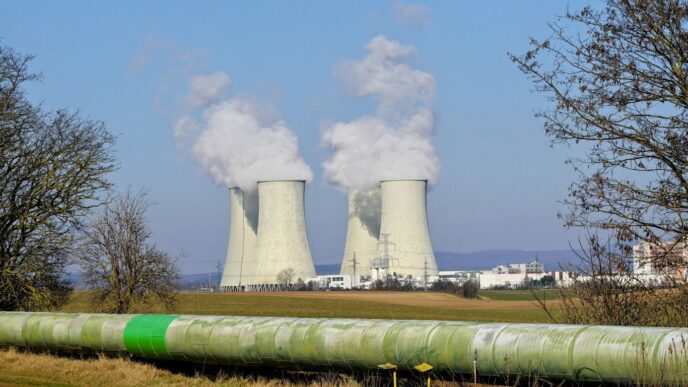

Britain is running out of time and running short on domestic biomass. The Labour government has committed to a zero-carbon electricity system by 2030, and renewables now supply just over half of UK electricity generation, a milestone that would have seemed ambitious a decade ago. But beneath that headline figure lies a structural vulnerability that planners, policymakers, and energy analysts are increasingly worried about: the United Kingdom currently imports around 95 per cent of the wood pellets it burns in large-scale biomass power stations, leaving a critical pillar of its renewable energy supply exposed to the same global price shocks that have rattled households and businesses since 2021.
The scale of the dependency is striking. Biomass and bioenergy together provided roughly 14 per cent of UK electricity generation in 2024, making it the second largest renewable source after wind. Yet wind itself has reliability gaps that biomass is relied upon to fill: in the year to March 2024, there were five separate periods in which wind generation dropped below 11 per cent of capacity for 24 hours or more, creating significant shortfalls that only dispatchable, fuel-based generation could cover. Biomass typically delivers a steady two to three gigawatts of dependable power during those gaps. The problem is that almost all the fuel feeding those plants comes from abroad.
“When you look at the UK’s bioenergy data, what stands out is not the ambition but the exposure. You have a country that has committed to net zero, that depends on biomass to stabilise its grid, and yet, it is sourcing most of that biomass from overseas supply chains it cannot control. That is not a long-term energy strategy. That is a procurement dependency dressed up as a climate solution.”
— Yetunde Adesiyan
Yetunde Adesiyan is a GIS Project Analyst and researcher whose published work sits precisely at the intersection of geospatial science, artificial intelligence, and bioenergy crop systems. Trained in Geographic Information Systems and Cartography at Sam Houston State University, where she graduated with distinction and a 4.0 GPA. As an emerging researcher, she is dedicated to developing analytical tools and contributing to the research and applied planning efforts focused on improving the evaluation, modeling, viable domestic cultivation, and spatial optimization of switchgrass as a sustainable bioenergy feedstock. Her focus on switchgrass, a hardy perennial grass with well-documented potential as a scalable bioenergy feedstock, is not incidental. It reflects a deliberate research orientation toward the crops and methods most likely to matter in the countries trying hardest to reduce fossil fuel dependency.
The solution that scientists and the Climate Change Committee increasingly point to is domestically dedicated energy crop production, expanding the cultivation of purpose-grown bioenergy feedstocks on UK soil to reduce import dependency and lay the groundwork for bioenergy with carbon capture and storage. That technology could remove up to 10 million tonnes of carbon dioxide from the atmosphere by 2035, covering 79 per cent of the removals required under the Seventh Carbon Budget. Analysts have calculated that even a one-year delay in getting these systems operational could add at least 1.2 billion pounds to the overall cost of meeting climate targets.
“It is well established that Elephant Grass (Miscanthus) is a preferred biomass crop in the UK, especially due to its viability within a temperate climate, but Switchgrass is a serious candidate for the UK’s domestic biomass expansion, and I do not think it receives the attention it deserves in the British policy conversation. It is resilient, it performs well on marginal land that would not otherwise support food crops, and it has a biomass yield profile that is genuinely competitive. The research question is not whether it can grow in the UK. The question is how geospatial and predictive modelling tools can identify exactly where it should grow, and at what density, to maximise both energy output and environmental benefit.”
— Yetunde Adesiyan
The UK currently has approximately 133,000 hectares under bioenergy crop cultivation, representing just 2.2 per cent of its arable land. Determining how, where, and at what environmental cost that figure could be responsibly expanded is not a political question. It is a geospatial and data science question. Adesiyan’s research addresses that challenge directly. Through UAV-derived vegetation indices, remote sensing, and spectral analysis of crop variability, her work produces the granular, spatially resolved data that planners need to assess land suitability, model yield variation across soil types and microclimates, and adapt cultivation strategies to local conditions.
“The limiting factor in domestic biomass expansion is not the land. The UK has more marginal and underutilised agricultural land than most of its policymakers realise. The limiting factor is the quality of the spatial data informing those decisions. If you are relying on coarse-resolution datasets and manual survey methods to identify energy crop sites, you will miss the variation that actually drives yield differences. UAV-derived imagery and spectral indices give you the resolution to see what ground-level surveys cannot. That gap in analytical precision is where a great deal of the UK’s biomass potential is currently being left on the table.”
— Yetunde Adesiyan
Her independent research continues to advance interpretable AI methods for vegetation health analysis and spatial agricultural modelling, with particular attention to how machine learning outputs can be made transparent enough to support real infrastructure decisions rather than simply generating predictions that practitioners cannot interrogate or trust. That emphasis on interpretability is not a technical footnote. In the context of land use planning, planning inquiries, and environmental impact assessments, the ability to explain and defend a spatial model’s outputs is as important as the accuracy of those outputs.
“There is a tendency in applied AI research to treat model accuracy as the primary measure of success. But in the context of land use and energy planning, interpretability matters just as much. A local authority considering whether to approve an energy crop development needs to understand why a model recommends a particular site, not simply that it does. Interpretable AI is not a compromise on performance. It is what makes the science usable by people who have to make decisions.”
— Yetunde Adesiyan
Beyond the bioenergy question, Adesiyan’s geospatial capabilities have broader application across the UK’s renewable energy infrastructure challenge. Wind farm site assessment, solar deployment planning, grid routing, and environmental impact modelling all depend on the kind of high-resolution spatial analysis and predictive modelling that her research develops. Her professional work in an integrated energy and geoscience company in Texas, where she manages complex geospatial datasets for operational and analytical decision-making, grounds that expertise in the practical realities of the energy sector rather than confining it to academic literature. She also volunteers as a Land Cover Observer under the NASA/GLOBE programme, contributing to land cover documentation and disaster-response mapping initiatives that are directly relevant to the climate resilience work the UK is rapidly scaling up.
“The UK’s renewable energy transition is not just an engineering problem or a finance problem. It is a spatial problem. Every turbine, every solar array, every energy crop field exists somewhere on the landscape, and the quality of the spatial analysis informing those siting decisions has a direct effect on project outcomes, community relationships, and environmental performance. What I find compelling about the UK context specifically is that the data infrastructure is largely there. The satellite coverage is good, the land registry data is detailed, and the environmental monitoring networks are mature. What is still needed is the analytical layer that turns all that data into actionable spatial intelligence.”
— Yetunde Adesiyan
As the United Kingdom presses toward its 2030 clean power target and works to build the domestic biomass base its net-zero strategy requires, the expertise that emerging researchers like Yetunde Adesiyan have developed, applying spatial intelligence and interpretable machine learning to the practical challenge of sustainable bioenergy crop systems, is not an academic nicety. It is an operational necessity. Britain would do well to pay attention.